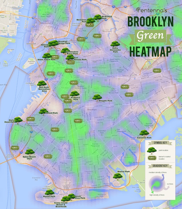
Even here in the big city, it’s nice to get some greenery every now and again. And we don’t mean the delivery kind or the kind that comes bagged from Trader Joe’s. We mean trees. Everyone loves trees and unless another hurricane happens, it’s always nice to live near some trees. But where, aside from Prospect Park, are all of the trees in Brooklyn? Well, there’s finally a map for that.
Rentenna’s Brooklyn Green Heatmap goes further than just telling you where Brooklyn’s parks are, as any cursory glance at a Google Map could do that. It also lets you know where you’ll find farmer’s markets and which parts of Brooklyn have the highest concentration of trees in the borough. That neon green that you’d normally associate with unhealthy, sliming radioactive ooze (or at least we would)? That’s where you’ll find the leafiest parts of Brooklyn.
Most of it isn’t too shocking, but it’s still nice to see it all laid out on a map. The Park Slope-Cobble Hill Corridor, and all down along Ocean Parkway are veritable gold mines of trees, if you allow our mixed metaphor, while Most of North Brooklyn could use a few more leafy friends. Especially out in Bushwick, Brownsville and East New York. And now that the South Brooklyn farmer’s markets are an open secret, the residents there can prepare for a whole slew of gentrifiers coming their way.
3 Comments
Leave a Reply


This map is SERIOUSLY flawed. Green-Wood Cemetery has nearly 8,000 trees and it is white on the map.
I agree with nyrich 54.
What are the criteria for the listed parks ? I miss some parks such as Carroll Park, with an acreage of 1.87 bigger than the listed Adam Yauch Park (acreage 1.36).
Great visualization – Would be interesting to overlay this with rental or home sale prices!
Re commenter above, the map says it plots street trees, so that would exclude trees located within parks or cemeteries (because people’s apartments are located on streets).